
Is the Betsiboka estuary a mangrove sediment filter or a sediment deposit ?
WIOMSA 12th symposium, poster presentation, October 10th, 2-3pm
THEME VII Estuaries and their resources
Madagascar, Mahajanga to Marovoay @ Yacinthe Lesecq
Authors
Hervé Dominique (IRD-SENS) dominique.herve@ird.fr
Laurent Robison (CNRE) robison.laurent@yahoo.fr
Hary-Riana Ranjalahy (CNRE, PhD student) riana_hary@yahoo.fr
Ravakiniaina Randrianatoandro (Univ. Antananarivo, PhD student) rabaniaina@gmail.com
Stefana Tabera Tsilefa (Univ. Fianarantsoa, PhD student)

Click on the poster to open it in full page
Background
The western coastline of Madagascar is subject to tides, waves, currents and the risk of marine submersion due to the sea level rise. This coastline is indented by rivers that flow into the sea with their fresh water and their sediment load. It is often beside these estuaries and deltas that ports are located with their discharge of pollutants.
The sediments washed down by the rivers have a direct impact on fragile coastal ecosystems: the mangroves, the coral reefs and the marine seagrass meadows, the first two having been more extensively studied than the third.
Beyond these ecosystems, sediments are dispersed in the sea on the continental shelf; but what may be observed by remote sensing is limited to the size and colour of the plume in the sea. The other important impact concerns infrastructures, the knowed sanding up of the port of Mahajanga, and the movements of the coastal sands related to the marine currents.
Objective, questions
We shall only study the mangroves in the context of the Betsiboka estuary exposed to the tides and the impact of the river (liquid flow rate and solid flow rate): how the mangroves of the Betsiboka estuary are conditioned by the input of sediment from the river of which we will study the lower catchment basin, from Ambato Boeny to Mahajanga. The sediments are deposited and accumulated in the downstream part of the estuary in the form of islands which, once emerged, are colonised by a mangrove with a monospecific population of Avicennia marina.
A first question: can the Bombetoka mangrove constitute a sediment filter, by retaining, by means of the mangrove roots, the sediments washed down by the river before they are discharged into the sea?
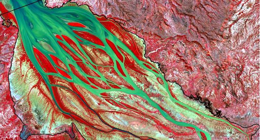
Bestiboka delta
Methods
Remote sensing, long term series of land cover in the estuary (old maps, Landsat, Sentinel 2).
The sediment load is obtained by measuring the suspended solids (MES) on the same dates and times as the passage of the optical satellite Sentinel 2, in such a way as to correlate the colour of the water and the measured quantity of suspended sediments. These measurements were performed upstream on the Ikopa, at Antsatrana, and downstream on the Betsiboka at Madirovalo, localised below the 0 tidal point where no difference may be observed between the high tide and the low tide.
Results
The extension of mangroves is limited upstream by the supply of fresh water, and by salinity when the clogging of the channels reduces access to water, leading to an irreversible evolution towards tans. It develops downstream on new emergent islands, which take on an elongated shape in the direction of the current and can then increase in length, and can also clog laterally when sediment deposits increase while the flow slows down.
The flow of the Betsiboka depends to a large extent on the flow of the Ikopa, which is increased at certain periods by the overflow of the Mahajamba. Pressure sensors, installed on the Ikopa upstream and on the Betsiboka downstream, allow the continuous monitoring of the water level, which is coupled with altimetric data during the passage of satellites. The intersection of some of these satellites is close to the old ORSTOM hydrological stations (1970s), which makes it possible to use this data for modelling. Supended sediments are measured by Sentinel 2 intersections.
A qualitative estimate of the filling of the estuary is made possible by monitoring the appearance and dynamics of about 200 islets over the past 120 years, by reconstructing the history of this islet population using old maps, then Landsat satellite images, and finally Sentinel 2 images.
Two effects of the input of these sediments are tested, one positive effect on the natural colonisation by the mangrove, of which we shall assess the rapidity, and one negative effect on the silting up of the estuary, the rapidity of which we shall also estimate. Such a record can only be achieved by modelling each of these phenomena and studying their interaction: modelling the evolution of these islets and their cover by the mangrove in order to establish a record and simulate the future dynamic of the estuary.
Conclusion
Other impacts could be assessed, such as navigation difficulties in the estuary and the propensity of fish to migrate downstream in search of deeper water. It is therefore essential to take into account the hydrological functioning of the river to understand the dynamics of the estuary.
Keywords
river, remote sensing, suspended solids, modelling, dynamics, coastal ecosystems