

Dercio Alberto,
PhD student at the University of Aix-Marseille, France
Biography
Dercio Alberto was born on June 18, 1993 in Maxixe, Mozambique. After obtaining a degree in History and Geography at the Pedagogical University of Mozambique, he went to France for a Master's degree in History, Civilizations and Heritage - Modern and Contemporary at the University of Aix-Marseille. Back in Mozambique, he taught history at Massinga Secondary School before joining the E-lows-Moz team as an intern. Subsequently he joined DIDEM on the co-supervised participatory observatory in the Incomati Delta.
Having obtained an ARTS grant, Dercio is back at the University of Aix-Marseille for his PhD.
Within the framework of DIDEM and the E-Flows program, you have set up a participatory observatory in the Incomati delta, could you tell us more about it?
The observatory allows researchers to collaborate with the different community actors directly linked to water uses.
It works in a hybrid mode, that is, we work in person (in the field), doing semi-directed interviews, guided visits and observations. We also do follow-up via WhatsApp. Regarding data sharing via WhatsApp, the observers have smartphones with which they take pictures and send them to me, we do not determine the number of pictures they have to send us or the time.
The idea is to ensure that the observatory's activities do not interfere with the normal functioning of their activities. These photos, both of fishing and agriculture, allow us to cross-reference and complete the data obtained by other research teams in the framework of the project. The photos also allow us to construct schedules of activities (agriculture) and identification of fish species (fishing).

Co-construction of hydrological scenarios for the Incomati delta workshop@S.Duvail
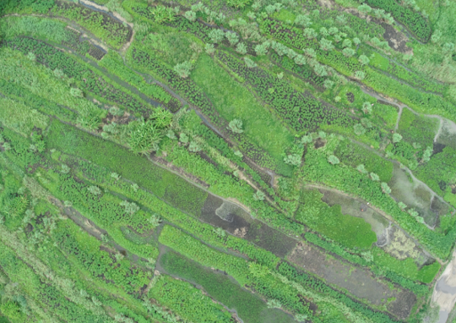
The rice fields and vegetable gardens seen from above, Incomati delta@S. Duvail & L. Cumbe
What will you study in your thesis?
I propose to analyze concomitantly two themes of colonial and post-colonial historiography that have been debated since the beginning of independence in African countries: on the one hand, the organization of chieftaincies, which can be considered a classic subject in contemporary history, and on the other hand, the sustainable management of natural resources - and in particular the governance of water and land issues, which has gained importance in the context of the debates on the anthropocene.
One of the key aspects of the environmental role of customary leaders in conserving and accessing natural resources (forest, water, etc.) is land power. Neither the extension of "private ownership" of land nor modern cadastral techniques (DUATs) have really succeeded in replacing the know-how, memory and legitimacy of customary chiefs.
This project does not propose to fill in the cartographic gaps of the territories of the local chiefs before the European presence. Instead, I try to focus on the beginning of the Portuguese occupation in Marracuene (1895) - a period that the different sociolinguistic groups of these districts were already settled in these areas - Homoíne and Marracuene. This choice is justified by (i) the roots of the expropriation and occupation of the land - it is a period that the Portuguese colonial administration set up agricultural projects in the floodplains of Incomati; and (ii) the methodological plan - it is undoubtedly the most documented period, which will allow us to carry out a more complete historical analysis of the problem, crossing with other sources.