
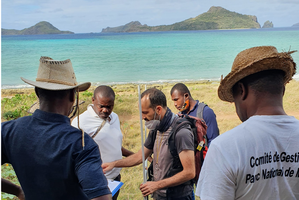
During its stay in the Comoros in August 2021, the DiDEM team specializing in islands and archipelagos of Comoros, did the groundwork for the launch of the observatory on vulnerability of Anjouan and Mohéli coasts to erosion.
Objectives of the observatory
1. Train surveyors in Anjouan and Mohéli, particularly in the two national parks of these islands, to enable them proficiently conduct beach profiles at regular intervals: twice a year at the same period in order to integrate seasonal variations and after exceptional episodes such as cyclones, heavy rains and other exceptional meteorological and marine phenomena.
2. Train the same surveyors on the creation of a database and its analysis using the PROFILER software (for Excel) in order to construct medium and long term data series on the evolution of the coastline of Mohéli and Anjouan.
Objectives of the launching mission
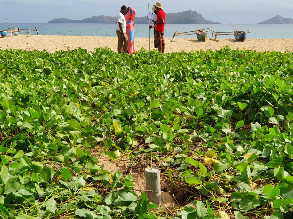
- Set up reference beacons on the six beaches being monitored during the first year of the observatory (three near Bimbini and three near Nioumachoi).
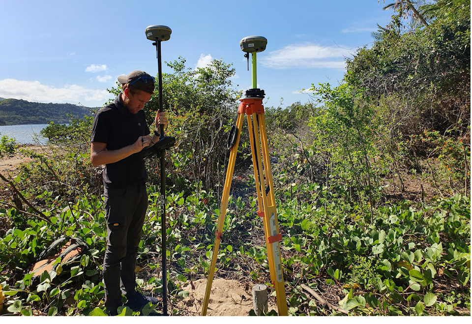
- Establish a topographic model of the six beaches being monitored using DGPS
- Elevate 18 beach profiles (three for each of the six beaches monitored)
- Train eco-guards on the use of the topometer so that they can monitor the beaches in the coming months
- Begin to organize the governance of the observatory by discussing with the national parks of Mohéli and Shisiwani two key points: the data analysis and its storage so that it can be used in decision-making and environmental management


Partners
Direction de l’Environnement/Gouvernorat d’Anjouan, Direction de l’Environnement de Mohéli, Parc national de Shishiwani (Anjouan), Parc national de Mohéli, Université des Comores, Centre Universitaire de Patsy à Anjouan
Team members
- Matthieu Le Duff, MCF (Associate Professor) of Geography at the Centre Universitaire de Mayotte, expert in the field of surveying;
- Yann Mercky, Assistant engineer in geological and antrophied environment studies, Centre Universitaire de Mayotte
- Nourddine Mirhani, former geography teacher at the Centre Universitaire de Patsy in Anjouan, who will be the trainer of the field agents in Anjouan and Mohéli;
- Gilbert David, director of research at IRD and former doctoral advisor to K. Sinane.;
Background and issues
Like all the high islands of the planet with a coastal plain where economic activities and habitat are concentrated, the Comoros archipelago is highly vulnerable to the rise in sea level caused by climate change. Over the past 40 years, the beaches of the Comoros have become significantly thinner, as evidenced by the examination of aerial photographs and old IGN maps and field observations made in recent years (Sinane, 2013).
Two causes can explain this thinning.
- removal of sand and coarser sediments from the beaches
- poor connectivity between the three sedimentary compartments that make up any beach: the fore-beach, located below the tidal range; the beach itself, located entirely in the intertidal zone; and the upper beach corresponding to the sedimentary stock accumulated during storms and spring tides at the upper limit of the beach.
K. Sinane's (2013) thesis showed the major role of sand removal in Anjouan as a factor aggravating the vulnerability of the coastline to the erosive impact of storm waves and swells. He also explains the impact of the use of sand as an economic resource for many coastal stakeholders. The use of volcanic sand, derived from the crushing of pozzolana, constitutes an alternative to the use of beach sand for self-construction of houses and the construction sector, but three factors hinder its use:
- pozzolana is more expensive to produce than beach sand because of the cost of crushing and sieving operations
- its production is “centralized”, it is limited to a few sites and requires transport logistics which are much more expensive than the “decentralized” production of beach sand
- if pozzolana is abundant in Grande-Comore due to the volcanic activity of Karthala, similar mining sites are rare in Anjouan and even more so in Mohéli. In the latter island, coastal erosion is also a major problem as reported by A. Lassi (2018) for the coastal area of Nioumachoa
Sinane et al, (2010) and Sinane (2013) have shown that beach profiles are a good way to monitor the evolution of coastline erosion and that the topometer presents a good compromise between the robustness of the measurement, its cost and the ease of use of the measuring device.
Inspired by the methods of Emery (1961), the topometer was developed in Reunion Island (Troadec, 2002, 2003; Cordier, 2007). It was successfully used in New Caledonia (Le Duff, 2018) and in the COSACO research program in Dunkerque. Though the information it produces is of a lower quality than that produced by differential GPS (DGPS) or terrestrial laser scanner (TLS) (Mahabot, 2016), learning to use it takes just a few hours.
The topometer is therefore a good tool to carry out topographic profiles of the beaches in a participatory way and providing enough evidence of future erosion of the coastline. It is also a methodological approach that fits perfectly with the protocols advocated by UNESCO (2007) regarding educational and awareness-raising tool for coastal erosion. A well-functioning beach with good connectivity between these three compartments is indeed the best way to reduce the vulnerability of sedimentary coastlines to wave and swell erosion.
The establishment of marine protected areas (MPAs) in part of the coastal waters of Mohéli and Anjouan could provide a favorable institutional framework for reducing the vulnerability of the coastline to coastal erosion [1] by prohibiting or severely controlling the removal of sand from the beaches. However, the managers of the MPAs of Anjouan and Mohéli must have the tools and methods to monitor the morpho-sedimentary dynamics and thus evaluate the evolution of erosion on the coastlines under their responsibility.
[1] Coastal erosion results in the loss of agricultural land and the destruction of coastal roads and dikes.
Financing
The first phase (2021) of this observatory is financed by the FSPI Economie Bleue. The FSPI (French Solidarity Fund for Innovative Projects, Civil Societies, Francophonie and Human Development) of the French Ministry of European and Foreign Affairs aims to raise awareness among the populations of the Western Indian Ocean region on the role and importance of the blue economy in their daily lives and to promote sustainable management of fisheries resources, while ensuring the protection of biodiversity and marine and coastal spaces.
In its second phase, the observatory will be financed by DIDEM project which will work towards ensuring that at the end of the project the Comorian partners will have complete autonomy in terms of monitoring and analysis of beach profiles.
Litterature references
Cordier, E. (2007) Dynamique hydrosédimentaire du récif frangeant de l’Hermitage/La Saline (La Réunion): Processus physiques et flux sédimentaires. Université de Provence., thèse de doctorat de géologie.
Emery, K. O. (1961) « A simple method of measuring beach profiles ». Limnology and oceanography, vol. 6, n°1, p. 90–93.
Lassi A. (2018). Le sud-est de l’île de Mohéli aux Comores, un littoral fragile, le cas de Nioumachoi. Université d’Antananarivo, master de géographie, parcours Milieux naturels et sciences de la terre.
Le Duff M. (2018). Les risques naturels côtiers en Nouvelle-Calédonie : contribution pour une gestion intégrée : De la caractérisation du risque à la participation citoyenne, quelques perspectives pour la prévention des risques aux îles Loyauté. Université de Nouvelle-Calédonie, thèse de doctorat géographie.
Mahabot, M.M (2016). Suivi morphodynamique des plages récifales de La Réunion en contexte d’observatoire. Université de la Réunion, thèse de doctorat de géographie.
Sinane, K. (2013). Les littoraux des Comores, dynamique d'un système anthropisé : le cas de l'île d'Anjouan. Université de la Réunion/IRD, thèse de doctorat de géographie.
Sinane K, David G., Pennober G., Troadec R. (2010). « Fragilisation et modification des formations littorales meubles sur l’île d’Anjouan (Comores) : Quand l’érosion d'origine anthropique se conjugue au changement climatique », VertigO - la revue électronique en sciences de l'environnement [En ligne], Volume 10 Numéro 3 | décembre 2010, mis en ligne le 20 décembre 2010.
Thomassin A. (2011) "Des réserves sous réserve" : acceptation sociale des Aires Marines Protégées : l'exemple de la région sud-ouest de l'océan Indien. Université de La Réunion/IRD, thèse de géographie.
Troadec, R. (2002) Suivi de l’évolution du profil des plages coralliennes de la Réunion 1998-2001 (Rapport Interne). Laboratoire Géoscience Réunion.
Troadec, R. (2003) Analyse de la prise en considération du phénomène d’érosion affectant les plages coralliennes à La Réunion (Rapport Interne) (p. 23). Université de La Réunion.
UNESCO (2007) Introduction à SANDWATCH: surveillance des plages: outil pédagogique pour un développement durable, Dossiers régions côtières et petites îles, 91 pages.